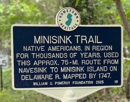
MINISINK TRAIL
- Program
- Subject
- Location
- Lat/Long
- Grant Recipient
-
Hometown Heritage®
-
People, Site
- 22 Mill Rd, Matawan, NJ 07747, USA
- 40.398474, -74.232493
-
Matawan Historical Society
MINISINK TRAIL
Inscription
MINISINK TRAILNATIVE AMERICANS, IN REGION
FOR THOUSANDS OF YEARS, USED
THIS APPROX. 75-MI. ROUTE FROM
NAVESINK TO MINISINK ISLAND ON
DELAWARE R. MAPPED BY 1747.
WILLIAM G. POMEROY FOUNDATION 2025
The Lenape are the indigenous people who resided on land that would become New York, New Jersey, Pennsylvania, and Delaware. The name Delaware was used to refer to the Native Americans living along the Delaware River and would later be used to refer to almost all Lenape people (https://delawaretribe.org/home-page/about-the-tribe/). Munsee-speaking Lenape lived in the Middle and Upper Delaware River Valley. Along the Atlantic highlands was the Navesink band of the Lenape, and the Minisink lived in the Upper Delaware River Valley in northwestern New Jersey, northeastern Pennsylvania, and New York.
The Minisink Trail was used by these groups for trade and seasonal migration. Mapped by 1747, the trail ran between Navesink to Minisink Island on the Delaware River. Minisink Island at the northern end of the trail is part of the Minisink Historic District, the National Historic Landmark also known as the Minisink Archeological Site. The district covers more than 1,320 acres along the Delaware River in Pennsylvania and New Jersey. Minisink, situated in an area of lowland in and around Minisink Island, is considered the most important settlement of the Munsee, and according to the National Park Service, the region is one of the most extensive, best preserved, and most intensively studied archeological sites in the Northeast (https://www.nps.gov/articles/watergap.htm). Over a century of archaeological excavations and study have documented a wealth of information regarding Native American burials, diet, and artifacts in this region, preserving a record of more than 10,000 years of human occupation. There are especially dense deposits located on the southernmost portion on the New Jersey side of the Minisink Archeological Site (NPS, NRHP Registration Form, 1993). At the coastal end of the Minisink Trail, along the north bank of the Navesink River, archaeological evidence such as shell heaps show significant use of the route for shellfish near the mouth of the river to the Atlantic Ocean (Atlantic Highlands: From Lenape Camps to Bayside Town, Paul D. Boyd, 2004).
By the mid-18th century, virtually all the Lenape people had been displaced from this region. However, small bands remained, and secondary sources claim that portions of the Minisink Trail were still being used by Native Americans as late as 1820.
Like other Native American paths, the Minisink Trail came into use by Europeans settling in the area in the late 17th century, sections of which served as the foundation for early roads. In addition, segments of the Minisink Trail were used as boundary markers for properties being conveyed in land sale deeds. This can be seen where the trail crossed through the community of Matawan in Monmouth County, New Jersey, with the route referred to in early deeds as a landmark in describing property being conveyed. Eventually, a portion of the trail in Matawan became known as Mill Road. As of 2025, Mill Road remains as a vestige of the earliest inhabitants in the region.